
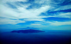
La Gomera - Isla Ronda
La Gomera the round island, is the second smallest island of the Canarian archipelago. From west to east it measures 36 km and from north to south 17 km, 370 square km. From here, Columbus once began its passage to the New World. Deep valleys with rugged cliffs and small plateaus make the appearance of the island. The highest peak, the peak of Garajonay, form the center of the island with a height of 1,487 meters.
La Gomera - Facts & Figures
![La Gomera,By Maximilian Dörrbecker (Chumwa) [CC BY-SA 2.0 (https://creativecommons.org/licenses/by-sa/2.0)], via Wikimedia Commons](https://static.wixstatic.com/media/69b47e_0eb174dce8c345c181aa23fc9a2c41a6~mv2_d_1500_1281_s_2.jpg/v1/fill/w_600,h_512,al_c,q_80,usm_0.66_1.00_0.01,enc_avif,quality_auto/69b47e_0eb174dce8c345c181aa23fc9a2c41a6~mv2_d_1500_1281_s_2.jpg)
-
The official language is Spanish, however the pronunciation differs considerably, for example the "S" seams unimportant buenos días will bueno día or gracias will be gracia. With English or German you do not come too far on La Gomera. In some of the hotels they speak some English or German, at Post, Bank,Taxi,Buses, Restaurants it will be a "mix of all languages".
-
El Silbio is a whistling language, a only at La Gomera used form of communication. The people needed a form of language to communicate over canyons and steep slopes. El Silbio can, if the wind is in favour, bridge 5 to 6 km. Simple news can be transferred from village to village.
UNESCO put it into the list of cultural assets and since 1999 it is a compulsory subject in the schools of Gomera
-
La Gomera is about 1,300 km from Spain and 300 km Africa
-
It is the third youngest of the Canary Islands (about 11 million years alt), it is a heavily eroded ocean island shield volcano.The vulcano stopped erupting about 3 million years ago.
-
Garajonay National Park was declared a UNESCO World Heritage Site in 1986.
-
Population 21.153, Provinz Santa cruz de Tenerife, Capital San Sebastian (population 8699)
-
The island was awarded the World Biosphere Reserve status in 2011 (in the excellent category)
-
La Gomera offers a network of over 600 km of trails.
Climate
-
The North-east trade winds and the Canary Current (a cool current (22°C) from the north which branches of from the Gulf stream near to the Azores. This reduces the temperature in summer by 2 to 3 °C , but provides a pleasant climate in the winter. Atlantic depressions can bring stormy weather to the islands.
-
La Gomera has a subtropical-oceanic climate along the coast, very mild and sunny most of the year.
It has spring-like winters and its warm and sunny in the summer, Rainfall mainly between October and March. The Canary Island can be reached by Atlantic depressions. In the summer it practically never rains. -
In Inland areas and with increasing altitude the weather gets cooler and wetter. The slopes exposed to the northeast trade winds receiving a good amount of rain and are therefore green. The southern slopes get rarely rain (below 13.5 inches).
-
Temperature: In the summer (July/August) Min (°C) 21°C / 70°F & Max 26°C / 79 °F; in the Winter (Dez.) Min (°C) 17°C / 63°F & Max 22°C / 72°F.
-
The Trade winds bring more humidity to the northern slopes and reducing the summer heat along the coast. The trade winds blow more strongly in the afternoon, being often moderate to strong.
-
The Calima (warm air masses fro Africa) is relatively rare in La Gomera then in the eastern islands of the Canaries. The Calima brings abnormal heat (exceeding 30 °C (86 °F) and light to moderate winds.
The Calima is more frequent in spring and summer. -
Hours of sun 6 hours (winter) to 10 hours (summer).
-
Swimming/sun bathing May to mid-October, the winter has a mild climate and often you can sunbath. The sea is cold in the winter (19°C / 66 °F)
-
In the Canaries the summer days are a bit shorter than in Europe and in the winter the days are longer tha in Europe.
-
In the winter bring light clothing for the day and jacket, sweater for the evening, a raincoat or umbrella is also a good idea.
-
In the summer don't forget to bring something for windy afternoons
-
Prepare yourself with the right clothing if you go hikking.
A Brief History
-
Fortunate Isles a fantasy of poets, praised by homer, somewhere after the Pillars of Hercules, at the End of the world, where the Elysian fields or the Fortunate or the Islands of the Blessed are, the Canary Islands?
-
Claudius Ptolemy was the first one showing the Canary Islands, he put the zero meridian at the cape Orchilla in El Hierro, at the western end of the known world at his times.
-
La Gomeras early history, like the other Canary Islands is a mystery. La Gomera was originally inhabited by Berbers from North Africa. Agriculture and fishing were the forms of livelihood for these first inhabitants.
-
The Canary Islands where known in the antique as the edge of the know world, Early Phoenician explorer (from Lebanon, Sidon & Tyre) most likely have been the first people to discover the Canaries. The Phoenician may have discovered Lanzarote, Fuerteventura and El Hierro, an Indize is the orchiella weed they have brought back. It was a plant used for colouring wool and silk.The Romans have explored the Canaries (most complete account of the canaries by Pliny the Elder. In the middle ages the Canaries disappeared from the knowledge and have been more myth than reality.
-
A Genoese fleet rediscovered the Canary Islands around the end of the 13th century (unter Lancelot Malocello).
Nicoloso de Recco made a detailed survey and recorded the language used by the aboriginals, the Guanchens, in 1341. In 1433 a papal bull gave rights over the Canaries to Henry the Navigator of Portugal, the decision was reversed in 1436 and the rights where awarded to the crown of Castile. In 1479 in a main clause of the "Treaty of Alcáçovas" the Castile's rights over the Canary Islands were recognised while Portugal won the exclusive right of navigating, conquering and trading in all the Atlantic Ocean south of the Canary Islands. Thus, Portugal attained hegemony in the Atlantic not only for its known territories but also for those discovered in the future. Castile was restricted to the Canaries., in return for Castilian recognition of Portuguese sovereignty over Fez and Guinea. (Source: Wikipedia) Read MORE
Here you will find some basic Spanish vocabulary for your journey and Information on Spanish food and wine.
A first impression of La Gomera
 |  |
|---|---|
 |  |
 |  |
 |  |
 |  |
 |  |
 |  |
 |  |
 |
Port of Call - San Sebastian
Arriving in San Sebastián - De La Gomera
Longitude of San Sebastián de la Gomera: -17.1098582
Latitude of San Sebastián de la Gomera: 28.0937998
Port
You arrive in the port of San Sebastian, at the eastern part of the island. From the port to the tourist office (Tourist information), it takes about 12 min (1 km). Google Maps
Small Cruise ships dock next to the ferry docks and a nice ferry terminal.
Car rentals: Four car rental companies are in the port. Many others are in walking distance (book in time) see Google Maps
CIGAR : Is located in the cruise port, Puerto cruceros de San Sebastián,38800 - San Sebastián de La Gomera, Phone: +34 902 244 444, Mo.- Fr.: 08:00-15:00 / 15:00-20:00, Sat.08:30-12:30 /
15:00-19:00; Sun. 08:30-12:30 / 16:00-19:00
Avis: Estación Maritima, Local E7, 38800 San Sebastián de La Gomera, Santa Cruz de Tenerife,
Tel.: 922 97 98 27, Mo.-Sun. 08.30 - 20.00,
Rent a Car PAE: Puerto de San Sebastián de La Gomera, 38800 San Sebastián de La Gomera, Santa Cruz de Tenerife, Tel.: 922 87 03 64
Mulagua cars S.L.: Estacion Marítima de San sebastian, local E6, 38820 San Sebastian de La Gomera, Santa Cruz de Tenerife, 922 87 28 76, Mo.-Sun. 08.30 - 20.30
Driving in Las Palmas
You can reach every point and place on the island with a car comfortable in a day. You will have to drive many hairpin bends, winding roads and it will be a permanent Up and Down. At blind bends use your horn. If it rains be very careful as rock fall and landslides are possible.
Rules & Fines:
-
Speed limit in towns 50 km/h, country road 90 km/h,
-
Safety belt are mandatory,
-
to tow are car is only allowed by tow trucks in Spain - call you car hire company,
-
white blue border marking means no parking except for a minute stop,
-
Fines (multas) are hefty in Spain, especially for over-speeding, the ignoring of no-passing zones and parking at yellow markings
-
legal alcohol limit is 0.5
Distances to attractions
Nature
Garajonay National Park: Google Maps 21 min 14.5 km
and Bosque del Cedro (Hermigua):
Valle de Hermigua: Google Maps 31 min 20.1 km
Valle Gran Rey Google Maps 76 min 50.7 km
Agulo: Google Maps 38 min 24.2 km
Mirador de Abrante in Agula Google Maps 55 min 33.6 km Vallehermoso: Google Maps 61 min 39.2 km
Los Órganos Google Maps 85 min 46.7 km
Mirador César Manrique Google Maps 59 min 41.0 km
Alajero Google Maps 49 min 32.2 km
Museums
Museum Naval (Maritime Museum) Google Maps 17 min 1.3 km by foot
Observatorium Roque de Los Muchachos Google Maps 76 min 43.1 km
Instituto de Astrofisica de Canarias Google Maps 10 min 5.2 km
Museo de la Seda las Hilanderas Google Maps 36 min 27.0 km
Museo Insular Google Maps 15 min 1.1 km by foot
Benahoarita Archaeological Museum Google Maps 46 min 33.8 km
Archaeological Park of Belmaco Google Maps 22 min 14.3 km
Sightseeing
Salinas Marinas de Fuencaliente Google Maps 22 min 14.3 km
Balcones de la Avenida Maritima Google Maps 22 min 14.3 km
Calle O'Daly Google Maps 22 min 14.3 km
Lookouts
Mirador de la Concepcion Google Maps 14 min 9.1 km
Mirador El Time Google Maps 60 min 45.8 km
Roque de Los Muchachos Google Maps 77 min 43.1 km
Mirador de la Cumbrecita Google Maps 42 min 30.4 km
![Bosque del Cedro, Garajonay, By Till Niermann (Own work) [GFDL (http://www.gnu.org/copyleft/fdl.html) or CC BY-SA 3.0 (https://creativecommons.org/licenses/by-sa/3.0)], via Wikimedia Commons](https://static.wixstatic.com/media/69b47e_3f6cd8f8a64e480daa5b339374db11ee~mv2.jpg/v1/fill/w_384,h_216,al_c,q_80,usm_0.66_1.00_0.01,enc_avif,quality_auto/69b47e_3f6cd8f8a64e480daa5b339374db11ee~mv2.jpg)
More Information
-
Time difference: The Canary Islands belong to the Western European Time Zone; Time from the Spanish mainland -1 hour
-
Opening Hours for shops and supermarkets (tiendas & supermercados), Mo.-Fr. 9.00 -13.00 & 17.00 - 19.00, Sa. only in the morning, in tourist areas supermarkets are also open on Sunday morning.
Market halls Mo.-Sa. until 14.00; Banks/Post Mo.-Sa. 9.00 - 14.00 -
Cash point are available in most towns.
-
The Health care system meets European standards, drugstores (green Maltese cross) open normal opening hours.
-
Important Telephone Numbers:
Emergency Services & Accident Tel : 112, Hospital General de la Gomera, San Sebastian
Tel:922 140 200, -
Mutua Universal San Sebastian De La Gomera Tel :922 141 171, Centro Médico Valle Gran Rey Sl Tel:922 805 629, Centro de Salud Valle Gran Rey Tel:822 171 187
-
Red Cross (Cruz Roja) 922 871 557
-
Police Station San Sebastian Tel: 922 141 072, Plaza Américas, 1st Floor Town Hall
-
Buses in Gomera: Despite the short distances in La Gomera the time for travel is long. From San Sebastián to Valle Gran Rey ihe bus takes about 2 hours to Playa de Santiago (34 km) it takes one hour, due to the landscape of Gomera. Outside of towns you can stop the public bus with a hand sign. For the bus time tables check here ( in Spanish).
The Buses are inexpensive San Sebastián Valle Gran Rey 5 Euro, Airport to San Sebastián 4 Euro. -
Taxis in La Gomera, http://www.taxigomera.com
Every bigger town-village has taxis stand. A green light on the roof or windscreen is the indication that the taxi is free. The Kilometer costs 0.50 Euro.
The following prices for taxis are an indication:
San Sebastian – Valle Gran Rey: 50-60€
Valle Gran Rey – Arure: 15€
Valle Gran Rey – Alto Garajonay: 30€
Valle Gran Rey – Vallehermoso: 40€
More practical Tips for La Gomera
What to see and what to do in San Sebastián de La Gomera
Sightseeing in San Sebastián Google Maps
San Sebastián, laying on the east coast of La Gomera is the biggest of the six communities. It is a contemplative small town with a population of 8.700. In 2015 the town received its first traffic light (at the harbour).
Sightseeing in San Sebastián is not a lengthy affair.
From the Plaza de Las Américas to the Calle Real
![Plaza de las Americás, San Sebastian, La Gomera,By CTHOE (Own work) [CC BY-SA 3.0 (https://creativecommons.org/licenses/by-sa/3.0)], via Wikimedia Commons](https://static.wixstatic.com/media/69b47e_98b7024327d14faaaf0ce6cdabdb7ced~mv2.jpg/v1/fill/w_310,h_480,al_c,q_80,usm_0.66_1.00_0.01,enc_avif,quality_auto/69b47e_98b7024327d14faaaf0ce6cdabdb7ced~mv2.jpg)
The Plaza De Las Américas is the heart and meeting point in town with kiosks and cafés. The former (Ayuntamiento) town hall (see picture) with its open arcade, wooden canary balconies and its turret clock is the architectonic eye-catcher at the plaza. In direction to the sea a colored mosaic, inserted into beach promenade, shows the route Columbus took from the Spanish mainland , over Gomera to Hispaniola.
A few steps north of the Plaza De Las Américas the Plaza de la Constitución with its Indian bay trees is located.
Here you will find the Custom House from the 17th century, a unimpressive small house. It is the oldest house in town. Here the export goods have been stored temporarily and it was the Island jail from time to time.
In the courtyard there is a fountain from which Columbus should have refreshed his water supplies for his voyage.
There is also a museum in the building, which informs about ship-routes Columbus has taken to the ¨"New World". Here starts also Calle Real.
A part of Calle Real is the pedestrian area of San Sebastian with Banks, restaurants, cafes, pensions, shops, modern boutiques, souvenir shops and apartment houses.
The church Nuestra Señora de la Acunción (1490) is the the most important sacral building in La Gomera.
The main façade with the red stone portal is probably from the first construction phase. Characteristic for this epoch are the rope-braided pointed arch and above the bell gable.The Portuguese influences can be seen, as they are also observed in Madeira and the Azores.
The locals call the left church door " Puerta del Perdón". The story is that the hated tyrant Hernán Peraza was kill by a aboriginal during the uprising in 1488. His wife Beatriz de Boballia then let the news spread that each of the concealing insurgents will be exempt from punishment, if he stands to his guilt, by going through the portal of the parish church. The trusting islanders came to the church, but the vengeful countess had everyone mercilessly executed.
The church was almost completely burned down by the Dutch and Algerian pirates in the 16th and 17th centuries. During the reconstruction, the church was extended to three naves, each nave with its own ceiling beams and portal. At the two side portals and the partly, with Canarian Tea Pine paneled ceilings showing the Mudéjar style (Moorish stile) of Andalusia.
To be seen in the church: The high altar (late baroque period) from the Canarian sculptor Luján Pérez, the artfully turned lattice at the chancel with the Jesus figure behind it and the wall painting about a a repelled pirate attack.
Casa Bencomo, a corner house (the left and right row of houses in front of the church) is a typical house from the 18th century. The archaeological museum is in the Calle de Torres Padilla (right side of the church). It has many valuable archaeological pieces from the aboriginal cultures as well as recreations of the discovery sites. Open: Summer: Tuesday to Friday from 10am till 7pm. Saturdays and Sundays from 10am till 2pm.Closed on Mondays.
Ermita de San Sebastian, only the side entrance with a pointed arch is an original part. The Ermita was 1994 renovated.
Casa Colón (Columbus House, Calle Real 56) is not the original house Columbus was staying, sometimes it is used for exhibitions.
Torre del Conde
at the end of Calle Rúiz de Padrón (Park de la Torre del Conde) the 18 m
high and with 2 m thick wall is the San Sebastians
landmark. It was build mid 15th century as protection against the
aboriginals and the pirates. It is one of the few buildings in town, which
is in its original state. Today there is a cartographic museum with
reproduction of maps of the Canary islands and town maps.
Open: Mo - Fr.10 '-13 and 16 - 18, Entrance is free.
Beaches
Playa de San Sebastián (Google Maps)
is the city beach of San Sebastián the locals use in the summer, in the winter the beach it is quit empty. it is a gray-black beach mixed with with coarse gravel.
Playa de la Cueva (Google Maps)
It names comes from a cave in which the Restaurant Club Náutico is build in. It is a black sandy beach. From here you have very good view of the 3717 m high Pico de Teide in Tenerife.
Shopping in La Gomera click here
Excursions from San Sebastián
By foot:
Parador-Hotel de la Gomera, follow the road La Pista (Google maps), 1,3 km 20 min.
"A parador (Spanish pronunciation: [paɾaˈðor]), in Spain and other Spanish-speaking countries, is a kind of luxury hotel, usually located in a converted historic building such as a monastery or castle. Parar means to stop, halt or stay." (Wikipedia)
The hotel ( build like a old Canary mansion) is situated on a cliff with a view of the habor, the city and in the distance Pico de Teide in Tenerife.
![Church of Our Lady of the Assumption, San Sebastian, La GomerañDiego Delso [CC BY-SA 3.0 (https://creativecommons.org/licenses/by-sa/3.0)], via Wikimedia Commons](https://static.wixstatic.com/media/69b47e_eaead258a89f49aca3505d95377b07eb~mv2.jpg/v1/fill/w_444,h_222,al_c,q_80,usm_0.66_1.00_0.01,enc_avif,quality_auto/69b47e_eaead258a89f49aca3505d95377b07eb~mv2.jpg)
![Torre del Conde, San Sebastian, La Gomera; Diego Delso [CC BY-SA 3.0 (https://creativecommons.org/licenses/by-sa/3.0)], via Wikimedia Commons](https://static.wixstatic.com/media/69b47e_a3711e4e7f274675ade1b1c05644166f~mv2.jpg/v1/fill/w_206,h_266,al_c,q_80,usm_0.66_1.00_0.01,enc_avif,quality_auto/69b47e_a3711e4e7f274675ade1b1c05644166f~mv2.jpg)
What to see and what to do in La Gomera
National Park Garajonay & the North
Roundtrip through the Garajonay National Park
Google Maps, 106 km, 6 hours with breaks
Around and partly through the middle of the Garajonay National Park goes this tour. Extensive views and the enchanting cloud forest provide lasting impressions of the green lung of La Gomera. The ride starts and ends in San Sebastián. But before that, you will visit other places in La Gomera North: Vallehermoso, El Cedro and Hermigua. In between, there is the opportunity to leave the car at Alto de Contadero and take a short hike. Various viewpoints offer further opportunities for a stop. The tour through the national park offers no possibility for a short cut. Time can only be reduced by refraining from sticking to one point or another. Of course you can start the tour from any other point on the island.
If you come with the cruise ship it would be a good idea to do this trip with a local guide to ensure being back in time.
1. San Sebastián de La Gomera, Santa Cruz de Tenerife - Starting point of the tour
2. Agulo
is located in the north of La Gomera. Every year on the 25th of April the Fiesta in honor of Saint Mark takes place, during which the young men of the village in front of the church of San Marco jump over blazing fires and thus prove their courage and their skill. The rest of the year you will find especially in the district La Montañet in the various bars and shops entertainment. In contrast, beautiful houses with courtyards and shingled roofs can be found in Las Casas. ......Read More
Santiago and the South
Google Maps, 37.6 km , 49 min or 42 km 62 min; By Ferry : 30 min, click here
Santiago is a sleepy resort in the south, whose only advantage is having the sunniest weather on La Gomera. The central Bergland in the middle of the island acts as a weather divide, it is dry (20mm rainfall in average a year) and low in vegetation, the mountain slopes are bare.
Playa de Santiago consists of four separate districts with 1800 inhabitants. Playa de Santiago is at the harbor. Some pensions, apartments, restaurants and supermarkets make up the tourist infrastructure.
In the district of Laguna de Santiago, the houses are partly built close to the hillside. From here a road with tight curves leads to the mighty rocky outcrop Lombada de Tecina. The Hotel Tecina with its Golf course (Fred Olsen S.A.) is located here.
Following the road, direction San Sebastian, you reach San Juanito, high above the valley floor, with picturesque square.
Opposite of Tecina, on the western side of the valley is Las Trincheras.
Beaches:
Please check the following website: www.gomeralive.com/beaches/
Trip: 1. San Sebastián , 2. Alajeró 3. Drago de Agalán, 4. Mirador de Tajaque, 5. Mirador Roque de Ojila,
6. Mirador Degollada de Peraza, 7. Benchijigua, 7.1 (Playa de Santiago) 8. San Sebastián
Google Maps, 108 km, 169 min, without Playa de Santiago 86.9 km 141 min
ALAJERO about 12 km from Playa de Santiago, Playa de Santiago (belonging to Alajeró) is the economical center of the south and Alajeró is the administrative center. To see: a renovated parish church which originates from the original 16th-century church of San Salvador. Alajeró is a starting point for a hike to Roque Calvario from which one can overlook large parts of the south La Gomeras. The hike takes about 1 hour. Carry on on the Carretera, driving through a arid, barren landscape where only spurge, cacti and agave grow.
Drago de Agalán - behind the Cruce del Imada is a parking lot on the left side, stop if you want to walk for an hour to see the 400 years old Drago de Agalán, the only not standing in a park or garden.
![San Juanito, La Gomera, by By Steffen 962 (Own work) [CC0], via Wikimedia Commons](https://static.wixstatic.com/media/69b47e_83d43bdcfa2f43a486611aeb11083d19~mv2.jpg/v1/fill/w_302,h_226,al_c,q_80,usm_0.66_1.00_0.01,enc_avif,quality_auto/69b47e_83d43bdcfa2f43a486611aeb11083d19~mv2.jpg)
![Las Trincheras, La Gomera, by By Steffen 962 (Own work) [CC0], via Wikimedia Commons](https://static.wixstatic.com/media/69b47e_4caac23e96914663a3bdba8baf5413c0~mv2.jpg/v1/fill/w_301,h_226,al_c,q_80,usm_0.66_1.00_0.01,enc_avif,quality_auto/69b47e_4caac23e96914663a3bdba8baf5413c0~mv2.jpg)
![Lombada de Tecina, La Gomera, By Steffen 962 (Own work) [CC0], via Wikimedia Commons](https://static.wixstatic.com/media/69b47e_05472ed478464460a5879f3ba0104d75~mv2.jpg/v1/fill/w_306,h_226,al_c,q_80,usm_0.66_1.00_0.01,enc_avif,quality_auto/69b47e_05472ed478464460a5879f3ba0104d75~mv2.jpg)
Valle Gran Rey - The valley of the great king
by Ferry: Valle Gran Rey - Playa de Santiago 40 minutes
![Statue des Hautacuperche im Valle Gran Rey, by Pediant at Dutch Wikipedia [GFDL (http://www.gnu.org/copyleft/fdl.html) or CC-BY-SA-3.0 (http://creativecommons.org/licenses/by-sa/3.0/)], via Wikimedia Commons](https://static.wixstatic.com/media/69b47e_7433c3c9a39a4510bc58841c576a55c7~mv2.jpg/v1/fill/w_359,h_270,al_c,q_80,usm_0.66_1.00_0.01,enc_avif,quality_auto/69b47e_7433c3c9a39a4510bc58841c576a55c7~mv2.jpg)
![Valle Gran Rey, by Rwxrwxrwx at English Wikipedia [CC BY-SA 3.0 (https://creativecommons.org/licenses/by-sa/3.0) or GFDL (http://www.gnu.org/copyleft/fdl.html)], via Wikimedia Commons](https://static.wixstatic.com/media/69b47e_6a2f5b4d5bf34d5fa88b31fc3a8ae38a~mv2.jpg/v1/fill/w_359,h_270,al_c,q_80,usm_0.66_1.00_0.01,enc_avif,quality_auto/69b47e_6a2f5b4d5bf34d5fa88b31fc3a8ae38a~mv2.jpg)
(Picture left)
Hupalupa (also Hupalupu or Hupalupo) was a king of the Guanches, the indigenous people of the Canary Islands. In 1488 Hupalupa took part in the revolt of the Gomeros, the inhabitants of La Gomera, against the castilian occupation. This occupation was led by the despotic ruler and feudal lord Hernán Peraza, who was murdered in November 1488 by Hautacuperche during this rebellion of the Guanches. Hautacuperche wanted to succeed King Hupalupa, but in a subsequent combat action his lost his life. The name of the fertile Valle Gran Rey (Valley of the Great King), to the west of the island La Gomera, still reminds of Hupalupa.
The individual districts of the Valle Gran Rey:
La Playa, with its beaches and a lovely promenade is a popular meeting spot;
La Puntilla, (between Vueltas and La Playa) is one of the favorite places in the Valle Gran Rey with its resorts and beaches;
La Calera lays on the slopes of the Valle Gran Rey with car-free alleys;
Vueltas is the habour area with small alleys and many bars. Im small habour fishing boats are next to yachts.
Borbalan in the Valle Gran Rey is a quiet place between the sea and the mountain slopes of the beautiful valley. Banana plantations and fruit trees line Borbalan, whose houses stretch from its traditional core to the waterfront.
El Guro is about 2.5 kilometers from the beaches of the Valle Gran Rey, it nestles on the mountainside and 130 steps lead to this district. Wonderful views from the top will reward you. Colorful facades and abstract sculptures and other artifacts, distributed around the houses indicate the bohemian side of the district.
Casa de la Seda presents itself with lush green and with rural charm. Casa de la Seda is directly opposite the chapel Ermita de los Reyes from 1515 - one of the most important churches of the Valle Gran Rey.
Upper Valle Gran Rey on left side seen from the sea are El Retamal, Lomo del Moral, Los Granados and other small settlements like La Rinconada; on right side seen from the sea are Lomo del Balo, Los Descansaderos, La Vizcaina, Higuera del Llano, El Hornillo and Chele. In the middle of terraced and fields many palm trees are the houses of the local community distributed. The districts are away from the bustle of the beach sides and tradition and you can enjoy the local colour.
 |  |
|---|---|
 |  |
 |  |
 |  |
 |  |
What to See and what to do in Valle Gran Rey
A very informative website is Gomeralive (Valle Gran Rey)
Whale Watching, Excursions, Sailing, Diving, Ecological tours (German), Timah (Hiking), Biking 1, Biking 2
![On a hiking trail north from San Sebastian, by By Jukka from HELSINKI, Finland (On a hiking trail northward from San Sebastian) [CC BY 2.0 (http://creativecommons.org/licenses/by/2.0)], via Wikimedia Commons](https://static.wixstatic.com/media/69b47e_1cd67fbc3f7a4a2190088529a64366d0~mv2.jpg/v1/fill/w_283,h_190,al_c,q_80,usm_0.66_1.00_0.01,enc_avif,quality_auto/69b47e_1cd67fbc3f7a4a2190088529a64366d0~mv2.jpg)

![Garajonay National Park, La Gomera, by By A.Stephan (Own work) [CC BY-SA 2.0 de (https://creativecommons.org/licenses/by-sa/2.0/de/deed.en)], via Wikimedia Commons](https://static.wixstatic.com/media/69b47e_622c12c8161a4baf8e29d360f5b8b55b~mv2.jpg/v1/fill/w_334,h_187,al_c,q_80,usm_0.66_1.00_0.01,enc_avif,quality_auto/69b47e_622c12c8161a4baf8e29d360f5b8b55b~mv2.jpg)